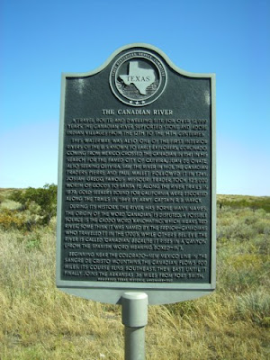
Along 287N driving north across Texas up to Colorado. Again, can't really remember the towns I was passing by where these historical markers were. Put it up to the stress of the trip. Hopefully I can take another trip down here in a year or so and get more information.
And truth to tell, you can't see a river from where this marker is. Perhaps this is the Texan dry season?
The Text:
A travel route and dwelling site for over 12,000 years, the Canadian River supported stone and adobe Indian villages from the 12th to the 14th centuries.
This waterway was also one of the first interior rivers of the U.S. known to early explorers. Coronado coming from Mexico crossed the Canadian in 1541 in his search for the famed city of Quivera. Juan De Chate, also seeking Quivera, saw th eriver in 1601. The Canadian traders Pierre and Paul Mallet followed it in 1741. Josiah Gregg, famous Missouri traer, took 125,000 worth of goods to Santa Fe along the river trails in 1821. Gold seekers bound for California were escorted along the trails in 1849 by Army Captain R.B. Marcy.
During its history, the river has borne many names. The origin of the word "Canadian" is disputed. A possible source is the Caddo word "Nanchating" which means "red river." Some think it was named by the French-Canadians who traveled it in the 1700s, while others believe the river is called "Canadian" simply because rises in a "canyon" (from the Spanish word meaning "boxed in."
Beginning near the Colorado-New Mexico line in the Sangre de Christo mountains, the Canadian flows 900 miles. Its course runs southeast, then east until it finally joins the Arkansas 36 miles from Fort Smith.
No comments:
Post a Comment